- Home
- Walking Tours
- Blog
-
St Peter's Basilica
- Altars
- Baldacchino
- Chair of St Peter
- Chapel of the Baptistery
- Chapel of the Bl. Sacrament
- Chapel of the Choir
- Chapel of the Pieta
- Crossing >
- Dome
-
Monuments
>
- Countess Matilda of Canossa
- Maria Clementina Sobieska
- Queen Christina of Sweden
- Pope Innocent VIII
- Pope Paul III
- Pope Gregory XIII
- Pope Gregory XIV
- Pope Leo XI
- Pope Urban VIII
- Pope Alexander VII
- Pope Clement X
- Pope Innocent XI
- Pope Alexander VIII
- Pope Innocent XII
- Pope Benedict XIV
- Pope Clement XIII
- Pope Pius VII
- Pope Leo XII
- Pope Pius VIII
- Pope Gregory XVI
- Pope Pius X
- Pope Benedict XV
- Pope Pius XI
- Pope Pius XII
- Pope John XXIII
- The Stuarts
- Nave
- Portico >
- Statue of St Peter
- Statues of Founder Saints
- Transept
- Tribune
- St Peter's Square
- Vatican Museums
- Sistine Chapel
- On This Day in Rome
-
Fountains
- Fontana della Barcaccia
- Fontana della Peschiera
- Fountain in Piazza Colonna
- Fountain in Piazza delle Cinque Scole
- Fountain in Piazza dell' Aracoeli
- Fountain in Piazza Nicosia
- Fountain in Piazza di S.M. in Trastevere
- Fountain of Moses
- Fountain of Neptune
- Fountains of Piazza Farnese
- Fountain of Ponte Sisto
- Fountain of the Acqua Paola
- Fountain of the Bees
- Fountain of the Cannonball
- Fountain of the Frogs
- Fountain of the Four Rivers
- Fountain of the Goddess Roma
- Fountain of the Lateran Obelisk
- Fountain of the Mask
- Fountain of the Moor
- Fountain of the Naiads
- Fountain of the Pantheon
- Fountains of Piazza del Popolo
- Fountain of the Porter
- Fountains of St Peter's Square
- Fountain of the Seahorses
- Fountain of the Triton
- Fountain of the Turtles
- Fountains of the Two Seas
- Four Fountains
- Rioni Fountains
- Street Fountains
- Trevi Fountain
- Venice Marries the Sea
-
Churches
- Chiesa del Gesù >
- Chiesa Nuova
- Lateran Baptistery
- San Bartolomeo all' Isola
- San Benedetto in Piscinula
- San Bernardo alle Terme
- San Carlo ai Catinari
- San Carlo al Corso
- San Carlo alle Quattro Fontane
- San Clemente >
- San Crisogono
- San Francesco a Ripa >
- San Giorgio in Velabro
- San Giovanni a Porta Latina
- San Giovanni dei Fiorentini
- San Giovanni in Laterano >
- San Girolamo della Carità >
- San Gregorio Magno
- San Lorenzo fuori le Mura
- San Lorenzo in Damaso
- San Lorenzo in Lucina
- San Luigi dei Francesi >
- San Marcello al Corso
- San Marco
- San Martino ai Monti
- San Nicola in Carcere
- San Pancrazio
- San Paolo fuori le Mura
- San Pietro in Montorio
- San Pietro in Vincoli
- San Saba
- San Salvatore in Lauro
- San Sebastiano fuori le Mura >
- San Silvestro in Capite
- San Vitale
- Sant' Agnese fuori le Mura
- Sant' Agnese in Agone
- Sant' Agostino
- Sant' Alessio
- Sant' Anastasia
- Sant' Andrea al Quirinale
- Sant' Andrea della Valle
- Sant' Andrea delle Fratte
- Sant' Antonio dei Portoghesi
- Sant' Apollinare
- Sant' Eustachio
- Sant' Ignazio di Loyola
- Sant' Ivo alla Sapienza
- Santa Caterina dei Funari
- Santa Cecilia in Trastevere
- Santa Costanza
- Santa Croce in Gerusalemme >
- Santa Francesca Romana
- Santa Maria ad Martyres
- Santa Maria degli Angeli
- Santa Maria dei Miracoli
- Santa Maria del Popolo >
- Santa Maria del Priorato
- Santa Maria della Pace >
- Santa Maria della Vittoria >
- Santa Maria dell' Anima
- Santa Maria dell' Orazione e Morte
- Santa Maria dell' Orto
- Santa Maria di Loreto
- Santa Maria in Aracoeli >
- Santa Maria in Campitelli
- Santa Maria in Cosmedin
- Santa Maria in Domnica
- Santa Maria in Montesanto
- Santa Maria in Trastevere >
- Santa Maria in Via
- Santa Maria in Via Lata
- Santa Maria Maddalena
- Santa Maria Maggiore >
- Santa Maria sopra Minerva >
- Santa Prassede
- Santa Pudenziana
- Santa Sabina >
- Santa Susanna
- Santi Apostoli
- Santi Cosma e Damiano
- Santi Domenico e Sisto
- Santi Giovanni e Paolo
- Santi Luca e Martina
- Santi Nereo e Achilleo
- Santi Quattro Coronati
- Santi Vincenzo e Anastasio
- Santissima Trinità degli Spagnoli
- Santissima Trinità dei Pellegrini
- Santissima Trinità di Monti
- Santissimo Nome di Maria
- Santo Stefano Rotondo
- Palatine
- Forum
-
Ancient Monuments
- Aqueducts
- Ara Pacis
- Arch of Constantine
- Arch of the Money-Changers
- Arch of Janus
- Aurelian Walls
- Baths of Caracalla
- Baths of Diocletian
- Castel Sant' Angelo
- Catacombs of Domitilla
- Circus Maxentius
- Circus Maximus
- Colosseum
- Column of Marcus Aurelius
- Column of Trajan
- Forum of Augustus
- Forum of Trajan
- Mausoleum of Augustus
- Nymphaeum
- Pantheon
- Ponte Fabricio
- Ponte Milvio
- Ponte Rotto
- Ponte Sant' Angelo
- Porta Maggiore
- Porta San Paolo
- Porta San Sebastiano
- Portico of Octavia
- Pyramid of Cestius
- Temple of Hadrian
- Temple of Hercules
- Temple of Portunus
- Theatre of Balbus
- Theatre of Marcellus
- Theatre of Pompey
- Tomb of Caecilia Metella
- Via Appia
-
Obelisks
- 'Minerveo' Obelisk
- 'Flaminio' Obelisk
- 'Matteiano' Obelisk
- 'Lateran' Obelisk
- 'Dogali' Obelisk
- 'Macuteo' Obelisk
- 'Solare' Obelisk
- 'Vatican' Obelisk
- 'Agonalis' Obelisk
- 'Sallustiano' Obelisk
- 'Quirinale' Obelisk
- 'Esquiline' Obelisk
- 'Pinciano' Obelisk
- 'Mediceo' Obelisk
- 'Torlonia' Obelisks
- 'Mussolini' Obelisk
- 'Marconi' Obelisk
-
Mosaics
- Gallery
- Palazzi
- Galleries & Museums
- Piazzas
-
Miscellaneous
- A Calendar of Saints
- A Literary Tour
- Antico Caffè Greco
- Art of the Cosmati
- Babington's Tea Rooms
- Barberini Bees
- Gian Lorenzo Bernini
- Borromini & the Baroque
- Catacombs
- Column of the Immaculate Conception
- Domes
- Equestrian Statues
- EUR
- Fasces
- Flood Plaques
- Funerary Monuments
- House of the Owls
- Jewish Ghetto
- Jubilee Years
- Knights of Malta
- Mithraism
- Monumental Complex of S. Spirito in Sassia
- Ponte Sisto
- Porta Pia
- 'Protestant' Cemetery
- Quartiere Coppedè
- Scala Santa
- Spanish Steps
- 'Talking' Statues
- Tiber Island
- Villa Borghese
- Vittoriano
- Rioni
- On This Day in Italy
-
Pictures from Italy
-
Florence
>
- A Literary Tour
- Anna Maria Luisa: Last of the Medici
- Casa-Galleria Vichi
- Column of Justice
- Column of St Zenobius
- Cosimo I de' Medici
- Cosimo II de' Medici
- Costanza Bonarelli
- David With Fig Leaf
- Elizabeth Barrett Browning
- Equestrian Statue of Cosimo I de' Medici
- Equestrian Statue of Ferdinando I de' Medici
- Festina Lente
- Floods
- Fontana del Bacchino
- Fontana dei Puttini
- Fountain of Neptune
- Fountains of the Marine Monsters
- Gian Gastone de' Medici
- Girolamo Savonarola
- Images of the Annunciation
- Little Devil
- Monument to Cellini
- Palazzo Bartolini-Salimbeni
- Palazzo Bianca Cappello
- Palazzo Fenzi
- Palazzo Viviani
- Perseus and Medusa
- Piazza Santa Maria Novella
- Pope Leo XI
- Porta della Mandorla
- Rape of the Sabine Woman
- Santa Maria Novella
- Canons' Palace
- Statue of Dante
- Theft of the Century
- Torre del Arnolfo
- Twelve Good Men
- Villa Gamberaia
- Wheel of the Innocents
- 'Wine Windows'
- Lazio >
- Tuscany >
-
Venice
>
- Ab Urbe Condita
- Acqua Alta
- Bartolomeo Colleoni
- Barque of Dante
- Burano
- Caffè Florian
- Daniele Manin
- Flagpoles
- Giustina Rossi
- Gondolas
- Harry's Bar
- Henry James
- House of Three Eyes
- King Victor Emmanuel II
- Map of Venice
- Martinmas
- Master of the House
- Palazzo Contarini Fasan
- Ponte Borgoloco
- Ponte Chiodo
- Punta del Dogana
- Scacciadiavoli
- Shrine of St Lucia
- Sior Antonio Rioba
- The 'Book Shitter'
- The Lion's Mouth
- Tommaso Rangone
- Torcello
- Venus
- 'Viennese Oranges'
- Wellheads
- Winged Lions
-
Florence
>
- Popes: 1417-Present
- Cloisters
|
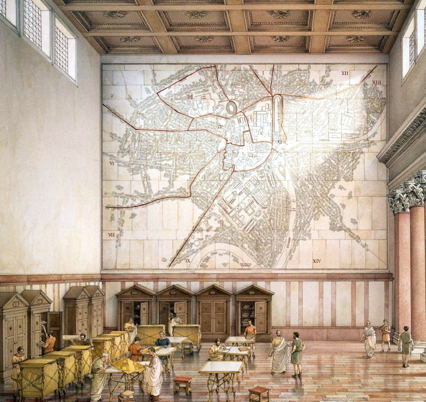
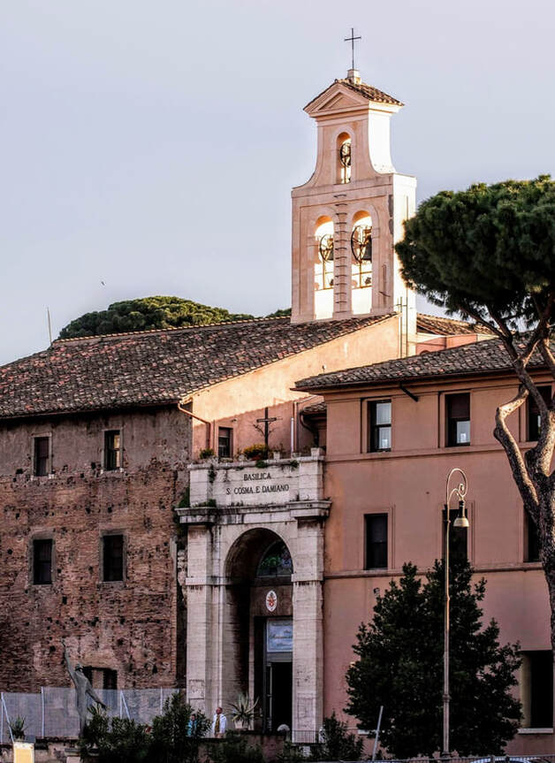
The large brick wall to the left of the entrance of the church of Santi Cosma e Damiano once sported a monumental marble map of ancient Rome, the Forma Urbis Romae. The wall, now peppered with clamp holes, was once completely veneered with 151 slabs of marble, on which was incised a scaled map (1:240) of the ancient city, with north at the bottom. The Forma Urbis Romae, also known as the Severan Marble Plan of Rome (c. 203-211 CE), was roughly 18 metres wide and 13 metres high (60 by 43 feet). It was mounted onto the wall of a room in the Templum Pacis, which had been built by the emperor Vespasian (r. 69-79). Sadly, only 10% of the map survives. Update: On January 10th 2024, the Museo della Forma Urbis opened in Rome. The museum has put on permanent display the surviving fragments of the map. Comments are closed.
|
My name is David Lown and I am an art historian from Cambridge, England. Since 2001 I have lived in Italy, where I run private walking tours of Rome.
Search Walks in Rome:
Most Popular Posts
Archives
May 2024
|
- Home
- Walking Tours
- Blog
-
St Peter's Basilica
- Altars
- Baldacchino
- Chair of St Peter
- Chapel of the Baptistery
- Chapel of the Bl. Sacrament
- Chapel of the Choir
- Chapel of the Pieta
- Crossing >
- Dome
-
Monuments
>
- Countess Matilda of Canossa
- Maria Clementina Sobieska
- Queen Christina of Sweden
- Pope Innocent VIII
- Pope Paul III
- Pope Gregory XIII
- Pope Gregory XIV
- Pope Leo XI
- Pope Urban VIII
- Pope Alexander VII
- Pope Clement X
- Pope Innocent XI
- Pope Alexander VIII
- Pope Innocent XII
- Pope Benedict XIV
- Pope Clement XIII
- Pope Pius VII
- Pope Leo XII
- Pope Pius VIII
- Pope Gregory XVI
- Pope Pius X
- Pope Benedict XV
- Pope Pius XI
- Pope Pius XII
- Pope John XXIII
- The Stuarts
- Nave
- Portico >
- Statue of St Peter
- Statues of Founder Saints
- Transept
- Tribune
- St Peter's Square
- Vatican Museums
- Sistine Chapel
- On This Day in Rome
-
Fountains
- Fontana della Barcaccia
- Fontana della Peschiera
- Fountain in Piazza Colonna
- Fountain in Piazza delle Cinque Scole
- Fountain in Piazza dell' Aracoeli
- Fountain in Piazza Nicosia
- Fountain in Piazza di S.M. in Trastevere
- Fountain of Moses
- Fountain of Neptune
- Fountains of Piazza Farnese
- Fountain of Ponte Sisto
- Fountain of the Acqua Paola
- Fountain of the Bees
- Fountain of the Cannonball
- Fountain of the Frogs
- Fountain of the Four Rivers
- Fountain of the Goddess Roma
- Fountain of the Lateran Obelisk
- Fountain of the Mask
- Fountain of the Moor
- Fountain of the Naiads
- Fountain of the Pantheon
- Fountains of Piazza del Popolo
- Fountain of the Porter
- Fountains of St Peter's Square
- Fountain of the Seahorses
- Fountain of the Triton
- Fountain of the Turtles
- Fountains of the Two Seas
- Four Fountains
- Rioni Fountains
- Street Fountains
- Trevi Fountain
- Venice Marries the Sea
-
Churches
- Chiesa del Gesù >
- Chiesa Nuova
- Lateran Baptistery
- San Bartolomeo all' Isola
- San Benedetto in Piscinula
- San Bernardo alle Terme
- San Carlo ai Catinari
- San Carlo al Corso
- San Carlo alle Quattro Fontane
- San Clemente >
- San Crisogono
- San Francesco a Ripa >
- San Giorgio in Velabro
- San Giovanni a Porta Latina
- San Giovanni dei Fiorentini
- San Giovanni in Laterano >
- San Girolamo della Carità >
- San Gregorio Magno
- San Lorenzo fuori le Mura
- San Lorenzo in Damaso
- San Lorenzo in Lucina
- San Luigi dei Francesi >
- San Marcello al Corso
- San Marco
- San Martino ai Monti
- San Nicola in Carcere
- San Pancrazio
- San Paolo fuori le Mura
- San Pietro in Montorio
- San Pietro in Vincoli
- San Saba
- San Salvatore in Lauro
- San Sebastiano fuori le Mura >
- San Silvestro in Capite
- San Vitale
- Sant' Agnese fuori le Mura
- Sant' Agnese in Agone
- Sant' Agostino
- Sant' Alessio
- Sant' Anastasia
- Sant' Andrea al Quirinale
- Sant' Andrea della Valle
- Sant' Andrea delle Fratte
- Sant' Antonio dei Portoghesi
- Sant' Apollinare
- Sant' Eustachio
- Sant' Ignazio di Loyola
- Sant' Ivo alla Sapienza
- Santa Caterina dei Funari
- Santa Cecilia in Trastevere
- Santa Costanza
- Santa Croce in Gerusalemme >
- Santa Francesca Romana
- Santa Maria ad Martyres
- Santa Maria degli Angeli
- Santa Maria dei Miracoli
- Santa Maria del Popolo >
- Santa Maria del Priorato
- Santa Maria della Pace >
- Santa Maria della Vittoria >
- Santa Maria dell' Anima
- Santa Maria dell' Orazione e Morte
- Santa Maria dell' Orto
- Santa Maria di Loreto
- Santa Maria in Aracoeli >
- Santa Maria in Campitelli
- Santa Maria in Cosmedin
- Santa Maria in Domnica
- Santa Maria in Montesanto
- Santa Maria in Trastevere >
- Santa Maria in Via
- Santa Maria in Via Lata
- Santa Maria Maddalena
- Santa Maria Maggiore >
- Santa Maria sopra Minerva >
- Santa Prassede
- Santa Pudenziana
- Santa Sabina >
- Santa Susanna
- Santi Apostoli
- Santi Cosma e Damiano
- Santi Domenico e Sisto
- Santi Giovanni e Paolo
- Santi Luca e Martina
- Santi Nereo e Achilleo
- Santi Quattro Coronati
- Santi Vincenzo e Anastasio
- Santissima Trinità degli Spagnoli
- Santissima Trinità dei Pellegrini
- Santissima Trinità di Monti
- Santissimo Nome di Maria
- Santo Stefano Rotondo
- Palatine
- Forum
-
Ancient Monuments
- Aqueducts
- Ara Pacis
- Arch of Constantine
- Arch of the Money-Changers
- Arch of Janus
- Aurelian Walls
- Baths of Caracalla
- Baths of Diocletian
- Castel Sant' Angelo
- Catacombs of Domitilla
- Circus Maxentius
- Circus Maximus
- Colosseum
- Column of Marcus Aurelius
- Column of Trajan
- Forum of Augustus
- Forum of Trajan
- Mausoleum of Augustus
- Nymphaeum
- Pantheon
- Ponte Fabricio
- Ponte Milvio
- Ponte Rotto
- Ponte Sant' Angelo
- Porta Maggiore
- Porta San Paolo
- Porta San Sebastiano
- Portico of Octavia
- Pyramid of Cestius
- Temple of Hadrian
- Temple of Hercules
- Temple of Portunus
- Theatre of Balbus
- Theatre of Marcellus
- Theatre of Pompey
- Tomb of Caecilia Metella
- Via Appia
-
Obelisks
- 'Minerveo' Obelisk
- 'Flaminio' Obelisk
- 'Matteiano' Obelisk
- 'Lateran' Obelisk
- 'Dogali' Obelisk
- 'Macuteo' Obelisk
- 'Solare' Obelisk
- 'Vatican' Obelisk
- 'Agonalis' Obelisk
- 'Sallustiano' Obelisk
- 'Quirinale' Obelisk
- 'Esquiline' Obelisk
- 'Pinciano' Obelisk
- 'Mediceo' Obelisk
- 'Torlonia' Obelisks
- 'Mussolini' Obelisk
- 'Marconi' Obelisk
-
Mosaics
- Gallery
- Palazzi
- Galleries & Museums
- Piazzas
-
Miscellaneous
- A Calendar of Saints
- A Literary Tour
- Antico Caffè Greco
- Art of the Cosmati
- Babington's Tea Rooms
- Barberini Bees
- Gian Lorenzo Bernini
- Borromini & the Baroque
- Catacombs
- Column of the Immaculate Conception
- Domes
- Equestrian Statues
- EUR
- Fasces
- Flood Plaques
- Funerary Monuments
- House of the Owls
- Jewish Ghetto
- Jubilee Years
- Knights of Malta
- Mithraism
- Monumental Complex of S. Spirito in Sassia
- Ponte Sisto
- Porta Pia
- 'Protestant' Cemetery
- Quartiere Coppedè
- Scala Santa
- Spanish Steps
- 'Talking' Statues
- Tiber Island
- Villa Borghese
- Vittoriano
- Rioni
- On This Day in Italy
-
Pictures from Italy
-
Florence
>
- A Literary Tour
- Anna Maria Luisa: Last of the Medici
- Casa-Galleria Vichi
- Column of Justice
- Column of St Zenobius
- Cosimo I de' Medici
- Cosimo II de' Medici
- Costanza Bonarelli
- David With Fig Leaf
- Elizabeth Barrett Browning
- Equestrian Statue of Cosimo I de' Medici
- Equestrian Statue of Ferdinando I de' Medici
- Festina Lente
- Floods
- Fontana del Bacchino
- Fontana dei Puttini
- Fountain of Neptune
- Fountains of the Marine Monsters
- Gian Gastone de' Medici
- Girolamo Savonarola
- Images of the Annunciation
- Little Devil
- Monument to Cellini
- Palazzo Bartolini-Salimbeni
- Palazzo Bianca Cappello
- Palazzo Fenzi
- Palazzo Viviani
- Perseus and Medusa
- Piazza Santa Maria Novella
- Pope Leo XI
- Porta della Mandorla
- Rape of the Sabine Woman
- Santa Maria Novella
- Canons' Palace
- Statue of Dante
- Theft of the Century
- Torre del Arnolfo
- Twelve Good Men
- Villa Gamberaia
- Wheel of the Innocents
- 'Wine Windows'
- Lazio >
- Tuscany >
-
Venice
>
- Ab Urbe Condita
- Acqua Alta
- Bartolomeo Colleoni
- Barque of Dante
- Burano
- Caffè Florian
- Daniele Manin
- Flagpoles
- Giustina Rossi
- Gondolas
- Harry's Bar
- Henry James
- House of Three Eyes
- King Victor Emmanuel II
- Map of Venice
- Martinmas
- Master of the House
- Palazzo Contarini Fasan
- Ponte Borgoloco
- Ponte Chiodo
- Punta del Dogana
- Scacciadiavoli
- Shrine of St Lucia
- Sior Antonio Rioba
- The 'Book Shitter'
- The Lion's Mouth
- Tommaso Rangone
- Torcello
- Venus
- 'Viennese Oranges'
- Wellheads
- Winged Lions
-
Florence
>
- Popes: 1417-Present
- Cloisters


